|
|
LANDSLIDE RESEARCH PROGRAMME
RESEARCH HIGHLIGHTS |
|
-- Back to the Landslide Research Programme Home Page --
|
Catastrophic Landslides: Effects, Occurrence, and Mechanisms
This volume documents further advances in our knowledge of catastrophic landslides since the pioneering compilations of the late 1970s by Barry Voight. It provides a worldwide survey of catastrophic landslide events written by leading authorities. Catastrophic Landslides begins by drawing upon South America to dramatically illustrate the impact of these phenomena on human populations. The occurrence of catastrophic landslides, including site-specific insights, is shown through six events of the past 20 years. Several other chapters focus on the mechanisms involved with catastrophic landsides both in relation to geologic factors in a particular geographic area as well as to specific geologic processes
Evans, S.G. and DeGraff, J.V.
(Eds). Catastrophic Landslides: Effects, Occurrence, and Mechanisms.
Reviews in Engineering Geology,
Volume XV,
The Geological Society of America, Boulder, Colorado. Link ISBN: 0813741157 Also available through Google Books: Link Reviewed by Michael W. Hart: |
|
|
Landslides from Massive Slope Failure This unique volume contains papers based on presentations and discussions at the NATO Advanced Research Workshop on Massive Rock Slope Failure; New Models for Hazard Assessment held in Celano, Italy in June 2002. 32 papers by 64 engineers, geologists, and geomorphologists from 16 countries address the issue of landslides from massive rock slope failure and associated phenomena (landslide tsunamis and landslide dams). Authors include some of the world’s leading authorities on the subject.
Amongst the thematic topics discussed are global frequency, impacts on society, analysis of initial rock slope failure, monitoring of rock slope movement, analysis and modeling of post-failure behaviour, volcanic landslides, and influences of massive rock slope failure on the geomorphological evolution of mountain regions. Regional contributions include reports on rockslides and rock avalanches in Norway, western Canada, the Andes of Argentina, the Karakoram Himalaya, the European Alps, the Appennines, and the mountains of Central Asia.
Rockslides and rock avalanches in the Central Asian republics of the former Soviet Union are discussed in detail for the first time in an English-language book. These landslides include the 1911 Usoi rockslide, that dammed 75 km-long Lake Sarez, and the 1949 Khait rock avalanche that may have killed up to 28,000 people. Both landslides were earthquake-triggered and both are located in Tajikistan. An additional highlight is a detailed description and analysis of large-scale artificial rock avalanches triggered by underground nuclear explosions during the testing programme of the former Soviet Union.
The volume is a contribution to defining the state-of-the-art in hazard assessment for massive rock slope failure and to global knowledge of the occurrence of landslides from massive rock slope failure in time and space. It is dedicated to the memory of noted Italian engineering geologist Professor Edoardo Semenza (1927-2002).
Evans, S.G., Scarascia Mugnozza, G., Strom, A., Hermanns, R.L. (Eds). Landslides from Massive Rock Slope Failure,
NATO Science Series IV. Earth and Environmental Sciences,
Vol(49),
Springer, Heidelberg, 689pp. Link ISBN: 978-1-4020-4036-8 |
|
|
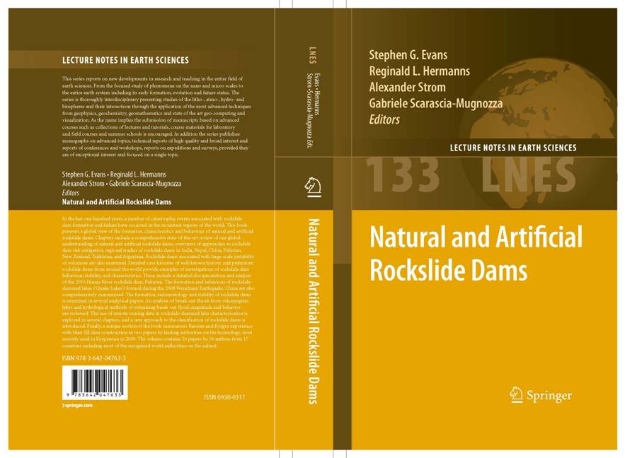
Natural and Artificial Rockslide
Dams In the last one
hundred years, a number of catastrophic events associated with rockslide dam
formation and failure have occurred in the mountain regions of the world.
This book presents a global view of the formation, characteristics and
behaviour of natural and artificial rockslide dams. Chapters include a
comprehensive state-of-the-art review of our global understanding natural and
artificial rockslide dams, overviews of approaches to rockslide dam risk
mitigation, regional studies of rockslide dams in India, Nepal, China,
Pakistan, New Zealand, and Argentina. Rockslide dams associated with
large-scale instability of volcanoes are also examined. Detailed case
histories of well-known historic and prehistoric rockslide dams provide
examples of investigations of rockslide dam behaviour, stability, and
characteristics. The formation and behaviour of rockslide-dammed lakes
("Quake Lakes") formed during the 2008 Wenchuan
Earthquake, China are also comprehensively summarised. The formation, sedimentology and stability of rockslide dams is examined in several analytical papers. An analysis of
break-out floods from volcanogenic lakes and hydrological methods of
estimating break-out flood magnitude and behaviour are reviewed. The use of
remote sensing data in rockslide-dammed lake characterisation is explored and
a new approach to the classification of rockslide dams is introduced.
Finally, a unique section of the book summarises Russian and Kyrgyz
experience with blast-fill dam construction in two papers by leading
authorities on the technology. Evans, S.G., Hermanns, R.L., Strom, A., Scarascia-Mugnozza,
G. (Eds). Natural and Artificial Rockslide Dams,
Lecture Notes in the Earth Sciences,
Vol(133),
Springer, Heidelberg. Link ISBN:
978-3-642-04763-3 |
|
|
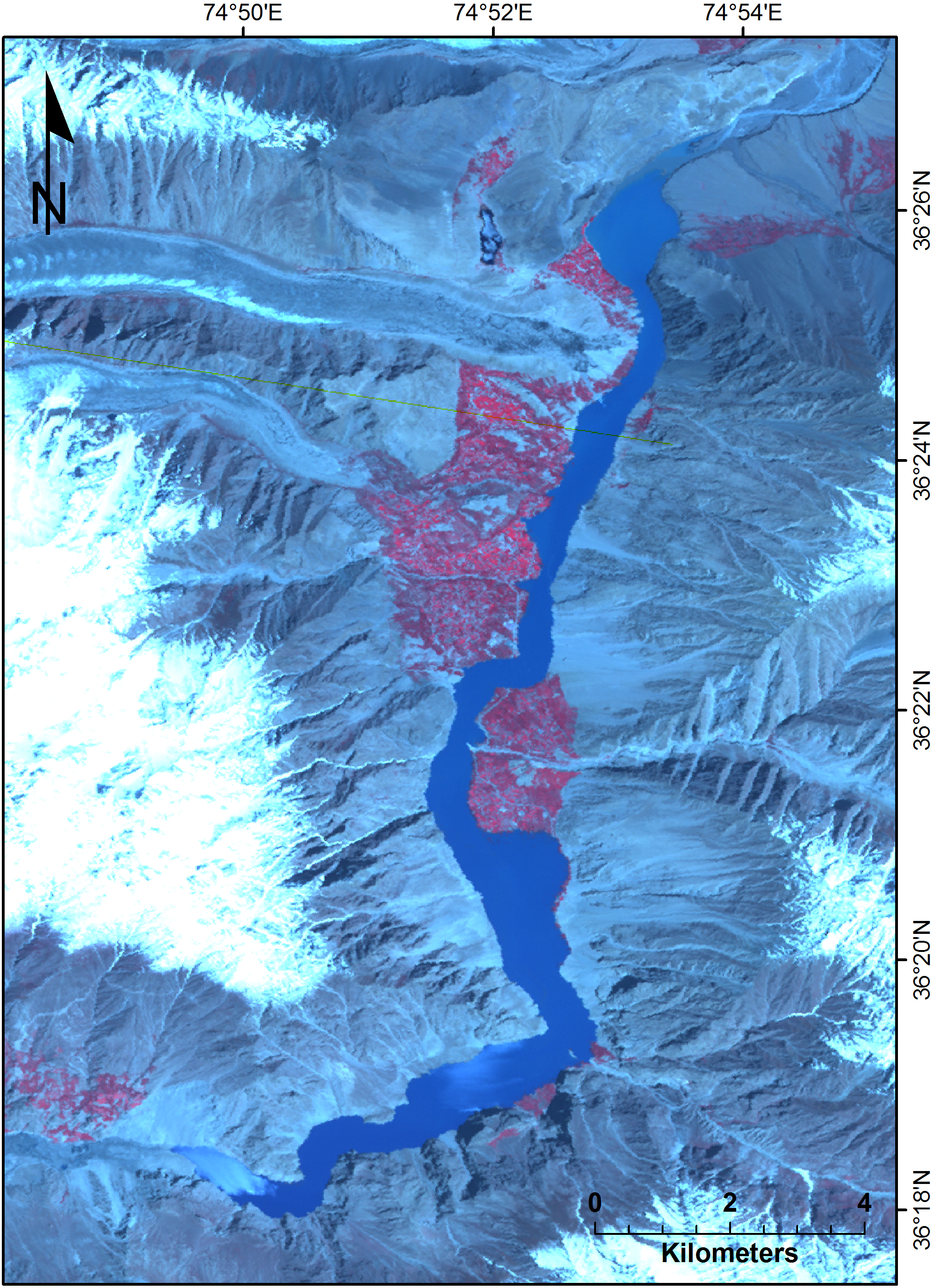
Rock Avalanche Dammed Lake Gojal, Attabad, northern Pakistan On January 4th, 2010, a ca. 50 M m3 rockslide formed a dam approximately 1200 m long, 350 m wide, and 125 m high. The initial mass movement killed at least 19 people, dammed the Hunza River at Attabad (northern Pakistan), and formed a large impounded lake (Lake Gojal). The lake began to overtop the rockslide debris on May 29th 2010, through a spillway contstructed by Pakistani authorities. At maximum, the lake was ca. 22 km long, covered and area of 12 km2, and contained a volume of 585 M m3 of water. Currently, the dam is still stable, with no credible estimates of catastrophic failure. Kargel, J.S., Leonard, G., Crippen, R.E., Delaney, K.B., Evans, S.G. and Schneider, J. 2010. Satellite monitoring of Pakistan's rockslide-dammed Lake Gojal. Eos, Vol(91), No(43), 394-395. Link |
|
|
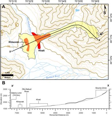
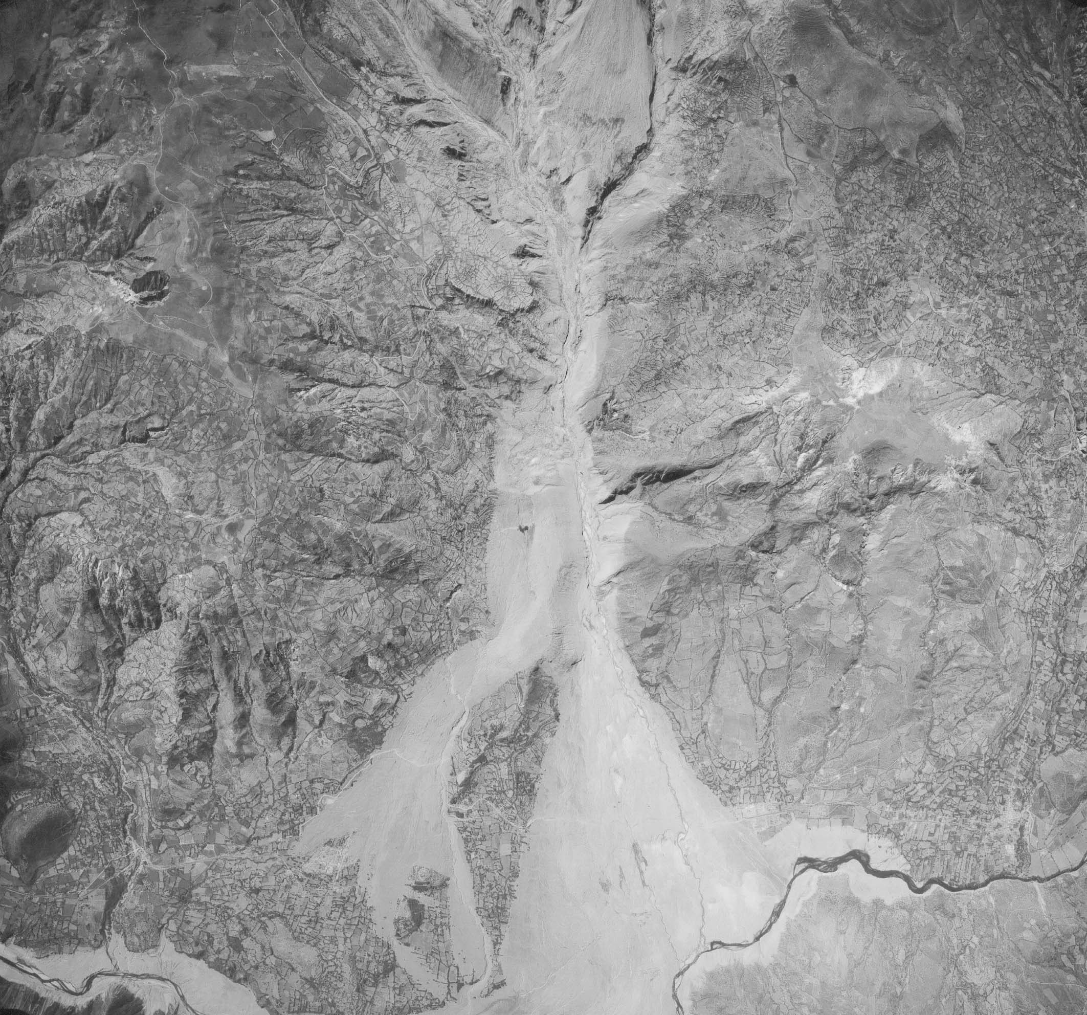
The 1949 Khait Rockslide-loess Flow In July 1949, the
M7.4 Khait earthquake triggered many hundreds of
landslides in a mountainous region near the southern limit of the Tien Shan Mountains, central Tajikistan. These landslides involved widespread
rock-slope failure as well as large numbers of flowslides
in loess that mantles the steep slopes of the region. The Khait
landslide involved a transformation of an earthquake triggered rockslide into
a very rapid flow by the entrainment of saturated loess into its
movement. The moving mass travelled a
horizontal distance of 7.41 km, while descending vertically 1421 m. We estimate the total volume of this event
as 75 M m3, an order of magnitude lower than previously published
estimates. We also estimate that the
total loss of life due to landslide inundation in the Khait
epicentral region is approximately 7200 people. Evans, S.G.,
Roberts, N.J., Ischuk, A., Delaney, K.B., Morozova, G.S. and Tutubalina,
O. 2009. Landslides triggered by the
1949 Khait earthquake, Tajikistan, and associated
loss of life. Engineering Geology, Vol(109), p195-212. |
|
|
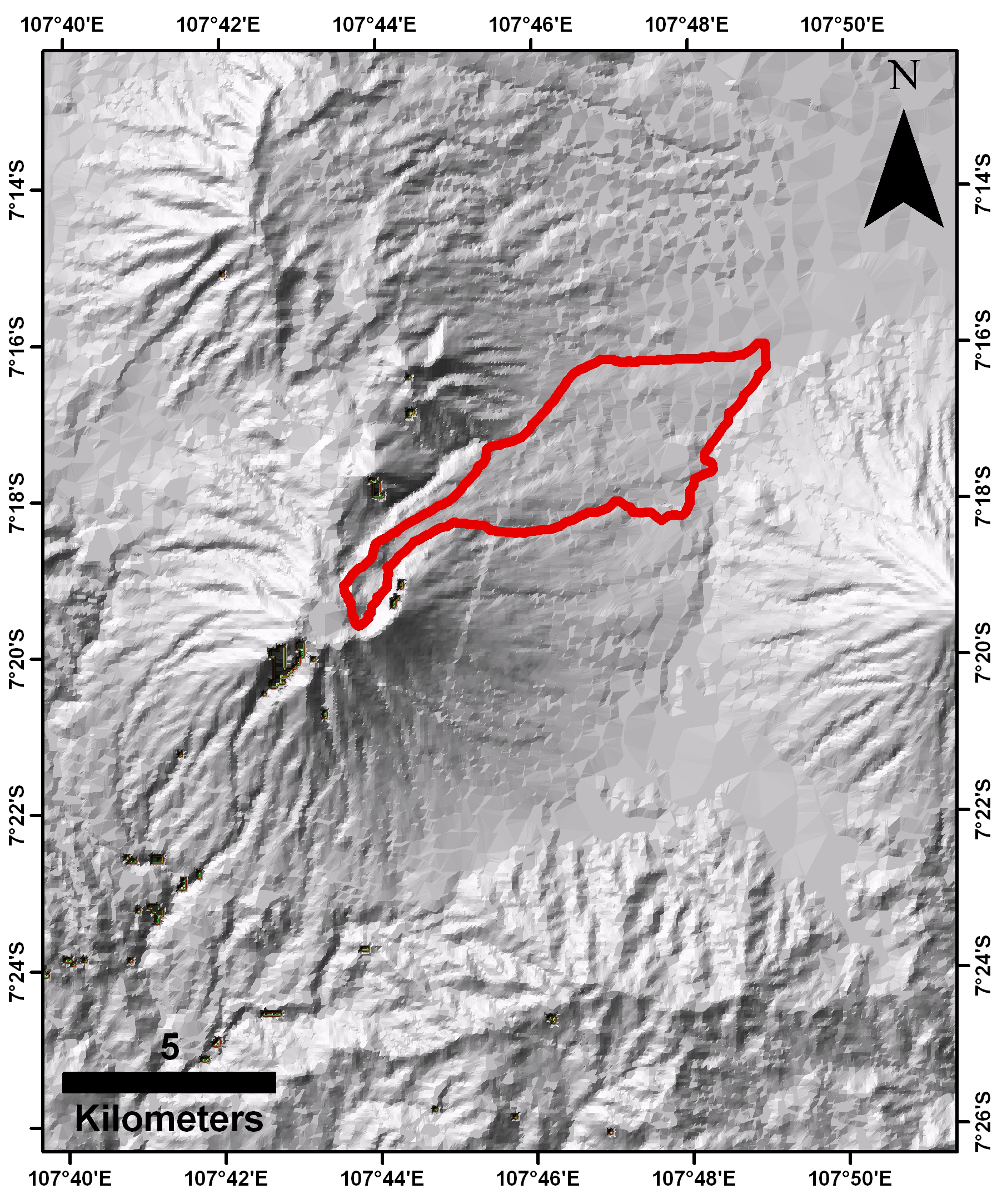
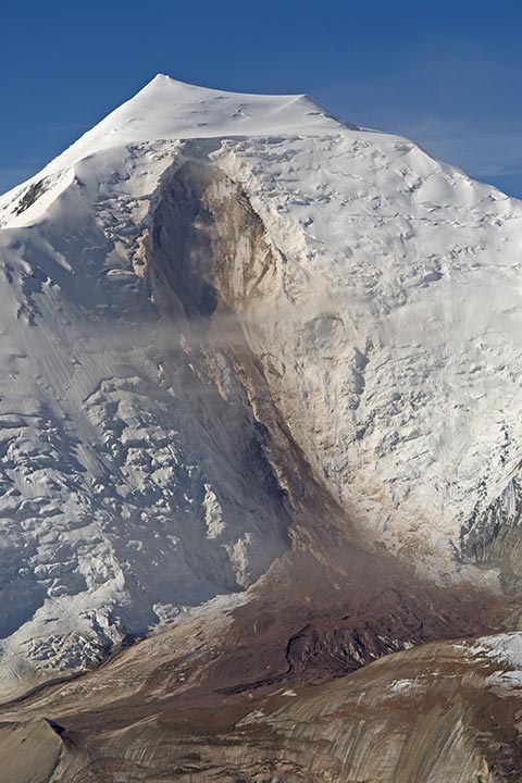
1772
Catastrophic Flank Collapse, Papandayan Volcano,
Indonesia The Papandayan stratovolano complex is located in the north west region of the Island of Java, Indonesia (07° 19' S / 107° 44' E). During the catastrophic 1772 eruption the north east flank collapsed, creating a massive debris avalanche. The failed mass travelled downslope to the NE over 10 kilometres, covering a total area of over 20 km2. This event destroyed 40 villages and killed almost 3000 people. This event is part of an on-going study researching global catastrophic landslides. |
|
|
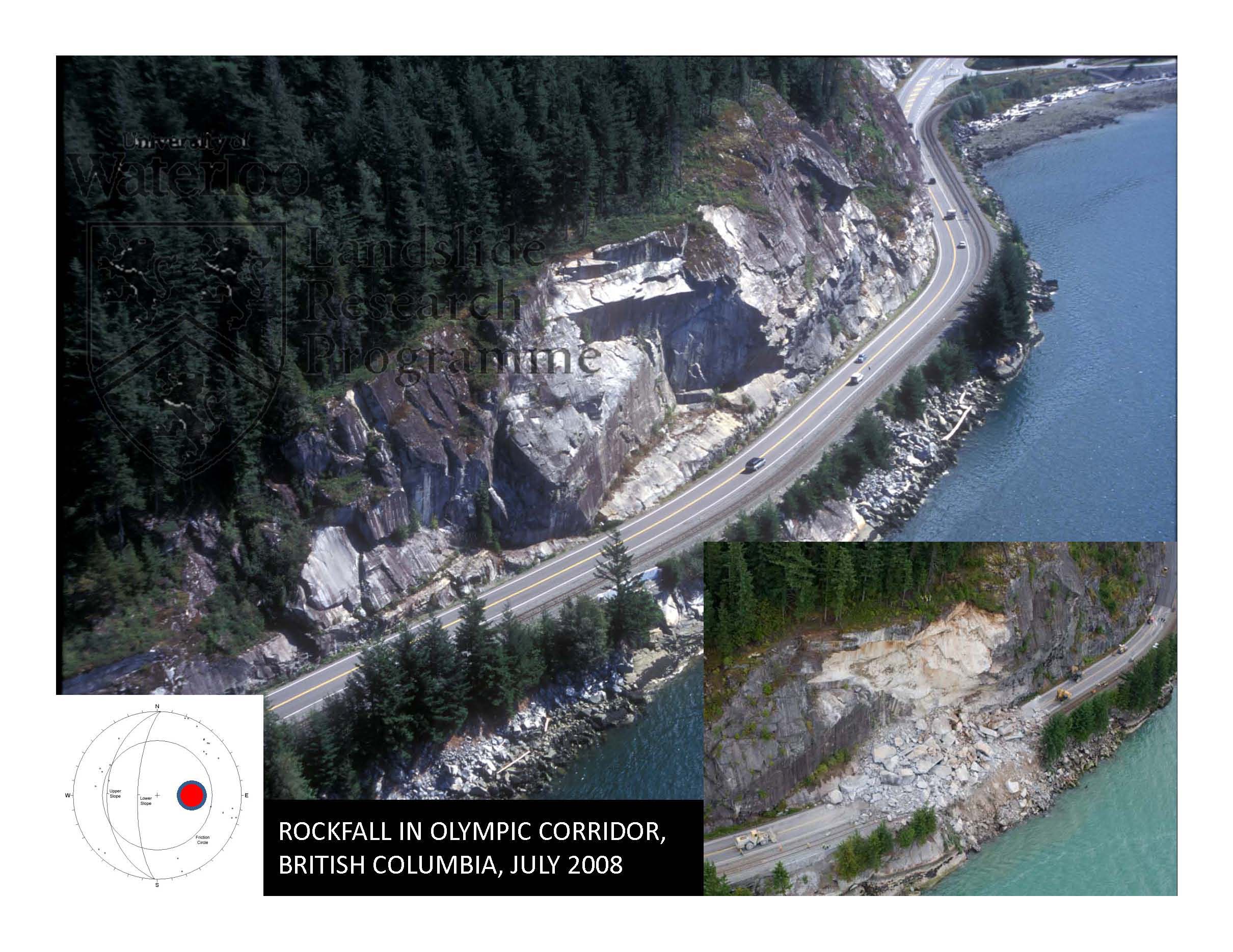
Sea To Sky
Highway (Olympic Corridor) Rockfall, British
Columbia, Canada The site of the July 31st 2008 Sea to Sky rockfall/rockslide was examined in 1997. The main photograph shows the site at that time. The photo at the lower right was taken soon after the 2008 event by Canadian Press. The slope consists of resistant Coast Plutonic Complex granite but as seen on the 1997 photograph the rock mass is characterized by more-or-less planar stress relief (sheeting) joints that dip west (downslope) towards Howe Sound. Undercutting of the slope during construction of highway in 1958 resulted in the sheeting joints daylighting in the rock slope (pole concentration is red dot on stereonet). The location of the 2008 rockfall is known as Porteau Bluffs, they run for just under 1 km along Howe Sound (49° 33’ 52.15”N; 123° 14’ 01.44”W), and the rock slopes along this section of highway exhibit similar rock mass characteristics to those involved in the July 2008 event.
|
|
|
Rock and Ice
Avalanches: Mount Steele, Yukon, Canada A large rock and ice avalanche occurred on the north face of Mount Steele, southwest Yukon Territory, Canada, on July 24, 2007. In the days and weeks preceding the landslide, several smaller avalanches initiated from the same slope. The ice and rock debris traveled a maximum horizontal distance 5.76 km with a maximum vertical descent of 2,160 m, leaving a deposit 3.66 km2 in area on Steele Glacier. The seismic magnitude estimated from long period surface waves (Ms) is 5.2. Modeling of the waveforms suggests an estimated duration of approximately 100 s and an average velocity of between 35 and 65 m/s. This landslide is one of 18 large rock avalanches known to have occurred since 1899 on slopes adjacent to glaciers in western Canada. We describe the setting, reconstruct the event chronology and present a preliminary characterization of the Mount Steele ice and rock avalanches based on field reconnaissance, analysis of seismic records and an airborne LiDAR survey. We also present the results of a successful dynamic simulation for the July 24 event. Lipovsky, P.S., Evans, S.G., Clague, J.J.,
Hopkinson, C., Couture, R., Bobrowsky, P., Ekström, G., Demuth, M.N., Delaney, K.B., Roberts, N.J.,
Clarke, G. and Schaeffer, A. 2008. The July 2007 rock and ice avalanches at
Mount Steele, St. Elias Mountains, Yukon, Canada. Landslides, Vol(5), No(4), p445-455. |
|
|
Rock
Avalanche and Debris Flows, Nevado Huascaran, Peru The 1962 and 1970 Huascaran mass movements, originated as rock/ice falls from the mountain's North Peak, transformed into higher-volume high-velocity mud-rich debris flows by incorporation of snow from the surface of a glacier below Huascaran and the substantial entrainment of morainic and colluvial material from slopes below the glacier terminus. Water for fluidization of the entrained material originated in the melting of incorporated snow and the liberation of soil moisture contained within the entrained materials. Eyewitness reports indicate very high mean velocities for the events; 17-35 m/s (1962) and 50-85 m/s (1970). The runout distances and velocity profiles of both events were simulated using DAN/W. Both mass movements continued downstream as debris floods (aluviones), that in 1970 reached the Pacific at a distance of 180 km. Evans, S.G., Bishop, N.F., Smoll, L.F., Murillo, P.V., Delaney, K.B. and Oliver-Smith, A. 2009. A re-examination of the mechanism and human impact of catastrophic mass flows originating on Nevado Huascarán, Cordillera Blanca, Peru in 1962 and 1970. Engineering Geology, Vol(108), p96-118. Link |
|
|
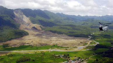
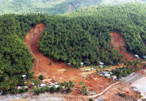
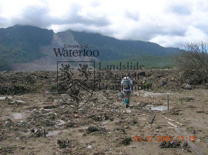
Rockslide-debris
avalanche on Leyte Island, Philippines In February 2006, a disastrous rockslide-debris avalanche occurred in tropical mountain terrain, on Leyte Island, Central Philippines. Over 1100 people perished when the village of Guinsaugon was overwhelmed directly in the path of the landslide. The landslide was initiated by the failure of a 450m high rock slope within the damage zone of the Philippine Fault where the rock mass consisted of sheared and brecciated volcanic, sedimentary and volcaniclastic rocks. Tectonic weakening of the failed rock mass had resulted from active strike-slip movements along the Philippine Fault which have been estimated by other workers at 2.5 cm/year. The landslide involved a total volume of 15Mm3, including significant entrainment from its path, and ran out a horizontal distance of 3800m over a vertical distance of 810 m, equivalent to a fahrböschung of 12°. Run-out distance was enhanced by friction reduction due to undrained loading when the debris encountered flooded paddy fields in the valley bottom at a path distance of 2600 m. A simulation of the event using the dynamic analysis model DAN indicated a mean velocity of 35 m/s and demonstrated the contribution of the paddy field effect to total run-out distance. There was no direct trigger for the landslide but the landslide did follow a period of very heavy rainfall with a lag time of four days. The rockslide-debris avalanche is one of several disastrous landslides to have occurred in the Philippines in the last twenty years. In terms of loss of life, the Guinsaugon event is the most devastating single-event landslide to have occurred worldwide since the Casita Volcano rock avalanche-debris flow which was triggered by Hurricane Mitch in Nicaragua in 1998. Evans, S.G., Guthrie, R.H., Roberts, N.J. and Bishop, N.F., 2007. The disastrous February 17, 2006 rockslide-debris avalanche on Leyte Island, Philippines: a catastrophic landslide in tropical mountain terrain. Natural Hazards and Earth Systems Science, Vol(7), p89-101. Link |
|
|
|
Department of Earth and Environmental Sciences Landslide Research Programme |
Last
Updated on: December 21, 2010 |
|